A unique platform created through a NASA/ESA (European Space Agency) collaboration—the Multi-Mission Algorithm and Analysis Platform (MAAP) using GEDI data—will play a key role in assessing global biomass stocks and changes as part of this U.N. work.
Biomass refers to the living part of vegetation systems, and it plays a crucial role in Earth’s climate. Destruction of vegetation releases carbon dioxide, a greenhouse gas, to the atmosphere. At the same time, vegetation pulls carbon dioxide out of the atmosphere and stores it as biomass. Biomass changes, especially in forests, can be both a key cause of climate change as well as a way to mitigate it.
Using open data from missions and initiatives conducted by multiple space agencies is one way global biomass can be consistently and periodically assessed. Biomass-related airborne and satellite missions include NASA’s Global Ecosystem Dynamics Investigation (GEDI) and Ice, Cloud, and land Elevation Satellite-2 (ICESat-2); ESA’s Sentinel missions; the joint NASA/ESA AfriSAR airborne mission; and the upcoming ESA BIOMASS and NASA/Indian Space Research Organization Synthetic Aperture Radar (NISAR) missions. In addition, undertakings such as ESA’s Climate Change Initiative (CCI) combine a suite of satellite data and provide higher-level products, including global biomass maps.
While NASA, ESA, and other national space agencies, along with the NewSpace commercial sector, are producing a wide range of biomass maps, transparency in biomass map products, flexibility of definitions, and the assessment of their inherent uncertainties are required for these maps to be useful in national policy-related biomass reporting, which supports undertakings like the GST. Analyzing how biomass maps from multiple sources can be harmonized for global use is a research objective perfectly suited for MAAP.
“The faster the science of space-based biomass estimation advances, the greater the risk of products being disparate, and hence disregarded or incorrectly used in the policy domain, which is detrimental to any contribution to efforts towards climate change mitigation,” says Dr. Neha Hunka, assistant research professor in the Department of Geographical Sciences, University of Maryland, and principal author on the research. “MAAP is a platform that brings both transparency and collaboration between teams involved in forest biomass estimation, allowing them to work through datasets consistently and comparably, and to communicate a clearer message on forest biomass stocks.”
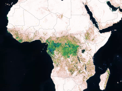
Image from the MAAP dashboard showing NASA Global Ecosystem Dynamics Investigation (GEDI) Level 4B biomass densities across central Africa. The data were acquired between 2019 and 2023. Darker colors (greens/blues) indicate areas of higher biomass densities. MAAP accessed November 29, 2023. Credit: NASA/ESA MAAP.