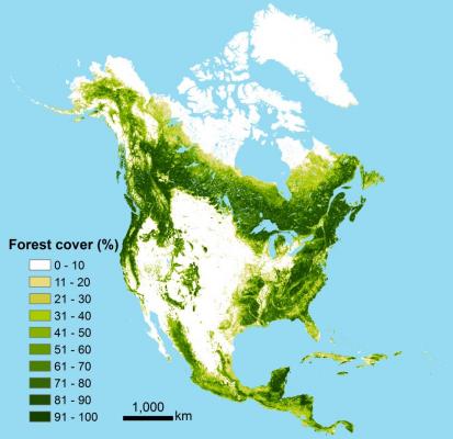
Ph.D Student Xiaopeng Song, Dr. Chengquan Huang, Dr. Min Feng, Dr. Joseph Sexton, Saurabh Channan and BSOS Dean, Dr. John Townshend recently published a paper entitled, “Integrating Global Land Cover Products for Improved Forest Cover Characterization: an Application in North America” in the International Journal of Digital Earth.
Abstract:
Six widely used coarse resolution global land cover datasets - Global Land Cover Characterization (GLCC), Global Land Cover 2000 (GLC2000), GlobCover land cover product (GlobCover), MODIS land cover product (MODIS LC), the University of Maryland land cover product (UMD LC), and the MODIS Vegetation Continuous Fields (MODIS VCF) disagree substantially in their estimates of forest cover. Employing a supervised regression tree model, these multi-source multi-resolution maps were integrated with Landsat-based land cover data as reference for an improved characterization of forest cover over North America. Evaluated using an withheld test sample, the integrated percent forest cover (IPFC) dataset has a root mean square error (RMSE) of 11.75%, substantially better than the 17.37% of GLCC, 17.61% of GLC2000, 17.96% of GlobCover, 15.23% of MODIS LC, 19.25% of MODIS VCF, and 15.15% of UMD LC, respectively. Although only demonstrated for forest, the methodology developed in this study has potential for improved characterization of other land cover types by integrating multiple map products.
To read the entire open access article, please click the link: http://www.tandfonline.com/doi/full/10.1080/17538947.2013.856959#.UshFlPRDvLO


