On April 14th, 2022, BS/MS student Frances Marie Panday defended her undergraduate honors thesis titled, “An Evaluation of the Climate Change Preparedness of Terrestrial Protected Areas in Maryland.” Panday, an Environmental Science and Policy (ENSP) major with a GEOG concentration in Marine and Coastal Management, is the first student in seven years to complete the ENSP Departmental Honors program, the first in a decade to receive ENSP High Honors, and the first ever to receive GEOG High Honors.
“I am really grateful to the department and my committee for their support and guidance throughout this process. Being able to conduct my own independent research was incredibly formative to my academic and professional career,” said Panday.
For the past year, Panday researched the ability of protected areas in Maryland to cope with future climate changes. Ultimately, she found that such areas were poorly prepared for the consequences of climate change.
“Marie’s thesis is a great example of important interdisciplinary research, combining qualitative and quantitative methods to address a key issue at the intersection of the grand challenges of climate change and biodiversity loss for the state,” said George Hurtt, a GEOG professor and the Chair of Panday's Honors Thesis Committee. In addition to Hurtt, GEOG Post-Doctoral Associate Rachel Lamb and ENSP Director/AGNR Professor Mark Carroll served on Panday's committee, which provided regular feedback and guidance throughout the thesis process. Both Lamb and Carroll strongly commended Panday's work:
"Marie did an excellent job combining skills in literature review and geospatial analysis to support climate-adaptive management across Maryland’s protected areas," said Lamb. Carroll was "impressed with the rigor of research Marie conducted and the clear manner in which all aspects of the research were communicated.”
Panday plans to explore the implications of her research for biodiversity and species conservation next year as a Master's student. “I am really excited to continue this work into my Master’s year,” she said.
The full abstract of Panday's thesis can be found below.
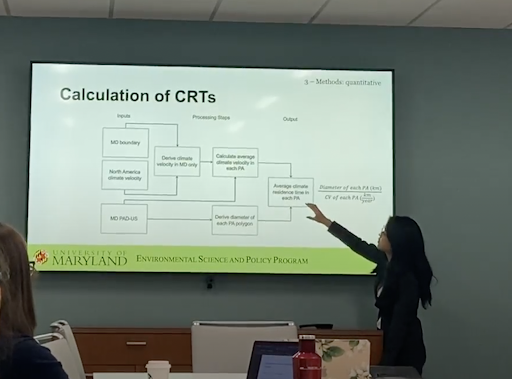
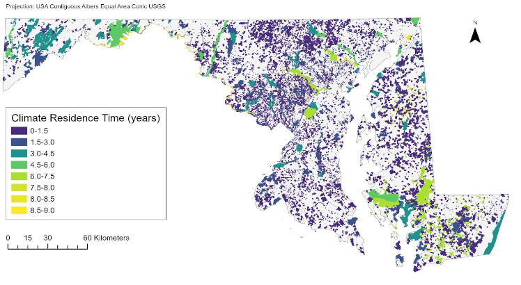
The rate at which the climate changes and the direction of these shifts is highly variable across the landscape. As proposed by Loarie et al. (2009), the concept of a climate change velocity (CV) adds a spatial component to the rate at which the temperature increases. Identifying where regions will experience the most significant changes in climate conditions is highly valuable for management of areas with high ecological and societal value, such as protected areas (PAs). To examine the relationship between climate velocity and protected areas, Loarie et al. (2009) proposes the climate residence time (CRT), which estimates the length of time (years) current climate conditions will remain in a given spatial location before shifting. Current management design and infrastructure of protected areas is outdated and may be ill-equipped to handle future changes in climate. Further, current work examining the relationship between protected areas and the CV is relatively new, but results are promising. Here, we evaluate the climate change preparedness of terrestrial protected areas in MD by first, quantifying the magnitude of future changes using the climate residence time, and second, evaluating their capacity to manage changes by qualitatively scoring their associated management plans for climate adaptation and/or mitigation language. This two-fold approach showed that most PAs have climate residence times less than or equal to 1.5 years and had plans with little to no language addressing climate change and its associated impacts. This suggests that PAs in MD are poorly prepared for future changes in climate. Given these results, including CVs and CRTs within PA management could improve a park’s adaptive capacity and simultaneously signal the need for a cross-coordinated management effort that transcends different management and governance scales
Contact email: fpanday [at] umd.edu