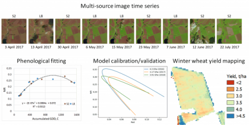
The overall scientific goal of the project was to develop a new algorithm and products for agriculture monitoring, namely crop yield assessment and mapping, by combining moderate spatial resolution images acquired by Landsat-8, Sentinel-2 and Sentinel-1/SAR remote sensing satellites. The project explored an increased temporal frequency of observations and coverage as well as combination of optical and microwave (SAR) imagery to generate new products that provided improved spatially explicit crop yield mapping at regional and field scales. The project was focused on three major crops, namely wheat, corn and soybeans, that are within the top 6 major commodities in the world and account for 25% of global crop production.
Key highlights:
- Multi-spectral satellite data can be used to assess crop yield at regional to field scale
- Performance is dependent on data frequency, spatial resolution, and spectral bands
- Temporal frequency and spatial resolution of satellite data are critical for explaining yield variability at field scale
- Green, red edge and NIR were the most important in explaining corn and soybean yields; red and NIR for wheat yields.
Project-related papers in peer-reviewed journals:
- Hall, J.V., Zibtsev, S.V., Giglio, L., Skakun, S., Myroniuk, V., Zhuravel, O., Goldammer, J. G., Kussul, N. (2021). Environmental and Political Implications of Underestimated Cropland Burning in Ukraine. Environmental Research Letters (accepted) https://iopscience.iop.org/article/10.1088/1748-9326/abfc04/meta
- Skakun, S., Kalecinski, N.I., Brown, M.G.L., Johnson, D.M., Vermote, E.F., Roger, J.-C., & Franch, B. (2021). Assessing within-Field Corn and Soybean Yield Variability from WorldView-3, Planet, Sentinel-2, and Landsat 8 Satellite Imagery. Remote Sensing, 13, art. num. 872. https://doi.org/10.3390/rs13050872
- Gitelson, A., Arkebauer, T., Viña, A., Skakun, S., & Inoue Y. (2021). Evaluating plant photosynthetic traits via absorption coefficient in the photosynthetically active radiation region. Remote Sensing of Environment, 258, art. num. 112401. https://doi.org/10.1016/j.rse.2021.112401
- Kussul, N., Lavreniuk, M., Kolotii, A., Skakun, S., Rakoid, O., & Shumilo, L. (2020). A Workflow for Sustainable Development Goals Indicators Assessment Based on High Resolution Satellite Data. International Journal of Digital Earth, 13(2), 309–321. https://doi.org/10.1080/17538947.2019.1610807
- Skakun, S., Justice, C. O., Kussul, N., Shelestov, A., & Lavreniuk, M. (2019). Satellite data reveal cropland losses in South-Eastern Ukraine under military conflict. Frontiers in Earth Science, 7, art. num. 305. https://doi.org/10.3389/feart.2019.00305
- Skakun, S., Vermote, E., Franch, B., Roger, J. C., Kussul, N., Ju, J., & Masek, J. (2019). Winter Wheat Yield Assessment from Landsat 8 and Sentinel-2 Data: Incorporating Surface Reflectance, Through Phenological Fitting, into Regression Yield Models. Remote Sensing, 11(15), art. num. 1768. https://doi.org/10.3390/rs11151768
- Franch, B., Vermote, E. F., Skakun, S., Roger, J. C., Becker-Reshef, I., Murphy, E., & Justice, C. (2019). Remote sensing based yield monitoring: Application to winter wheat in United States and Ukraine. International Journal of Applied Earth Observation and Geoinformation, 76, 112–127. https://doi.org/10.1016/j.jag.2018.11.012
Results of the project were included into the NASA report on “Commercial SmallSat Data Acquisition Program Pilot. Evaluation Report” (https://cdn.earthdata.nasa.gov/conduit/upload/
14180/CSDAPEvaluationReport_Apr20.pdf).
14180/CSDAPEvaluationReport_Apr20.pdf).


Project Sponsor
NASA

